
Well done! You have finished the Raheny Location Quick Quiz. How well did you look at the maps?
Let's look at the information we learned from both of the Raheny maps:
Let's look at the information we learned from both of the Raheny maps:
- Raheny is a place which is situated beside Dublin city.
- It is a suburb which is near the coast and it is north-east of the city centre.
- It has a village which is also called Raheny.
- There is a large park nearby, called St. Anne's Park, which goes almost as far as Dublin Bay.
- St. Anne's Park is Dublin's second-largest park.
Ā - The largest park in Dublin is Phoenix Park.
- There is a fishing port not far from Raheny called Howth.
- It is situated on a small peninsula. If you want to visit Raheny you could come by ferry to Dublin Harbour or Dun Laoghaire. You could also travel by airplane because Dublin Airport is about 8km from Raheny.
- Raheny village has a railway station on Station Road.
- A river which is called the Santry river flows through the village.
Ā - An island called North Bull Island can be reached by taking a short journey and crossing a road called Causeway.
- The place on the island called Dollymount is a beach. It is about 5km long.
- Raheny is near to Dublin city centre.
- The city is only about 8km away.
- A large coastal road connects Raheny to the city.
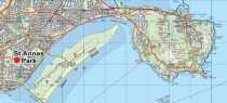
What does the map below tell about St. Anne's Park?
Raheny: Fishing Port and Beach nearby
Look for more information on this map. It shows a fishing port as well as a beach near Raheny.
Click on the image below to get a closer view. Can you see if St.Anne's Park is located north or south of the railway line?
Ā
Map 3
Ā
 Enlarge image

St.Annes map
Can you see any schools on this map? District Scale on the original is 1: 50,000. The map on the screen has been enlarged
Courtesy of the Ordnance Survey IrelandSt.Annes map
Courtesy of the Ordnance Survey Ireland
Courtesy of the Ordnance Survey Ireland
St.Annes map
Can you see any schools on this map? District Scale on the original is 1: 50,000. The map on the screen has been enlarged
Courtesy of the Ordnance Survey IrelandDistrict Scale on the original is 1: 50,000. The map on the screen has been enlarged.